Distributed Tile Processing
with
GeoTrellis and Spark
The Challenge
How do we work with very large raster data?
Specifically...
How do we work with the
NASA NEX Down-sampled Climate Projections (NEX-DCP30)
open data set?
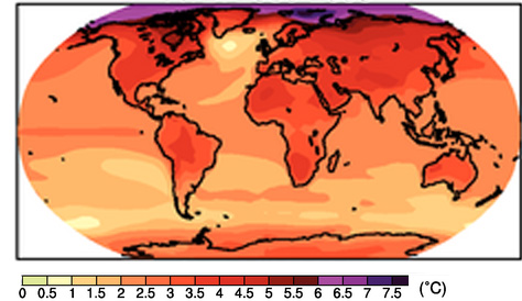
What is NEX Climate Projection data?
Global Circulation Models
Models for predicting world temperature and precipitation.
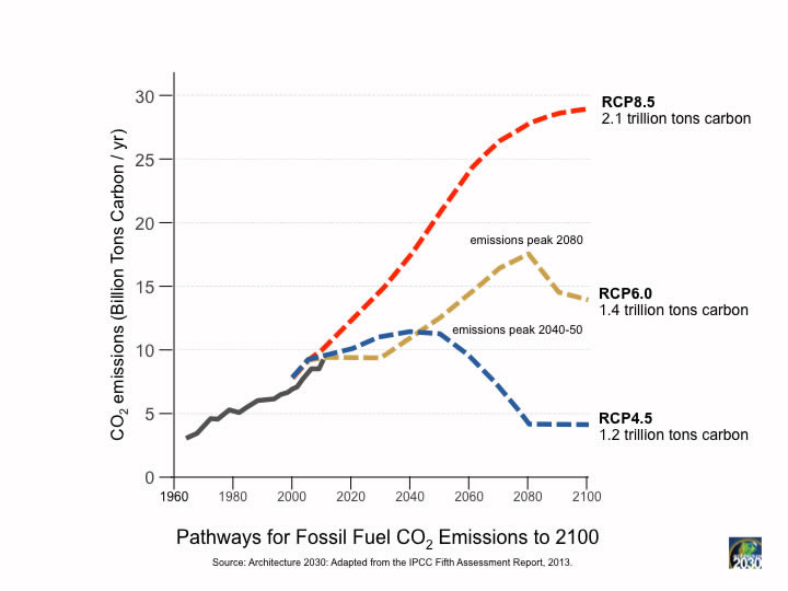
IPCC Assessment Report
- IPCC = Intergovernmental Panel on Climate Change
- Assessment Report 5 (AR5) published in 2014.
- More than 800 authors
3 Key Categories:
-
Model
- 33 different models
- Model Ensembling
-
Dataset
- Temperature MAX
- Temperature MIN
- Precipitation
-
Scenario
- Historical
- Future RCPs
Representative Concentration Pathways
NEX Down-sampled Data
-
Monthly data over conterminous US
- Historical from 1950 - 2006
- 4 RCP scenarios from 2006 - 2099
- 8190 netCDF files on S3 - s3://nasanex/NEX-DCP30
- 15.3 TB in compressed GeoTiff tiles.
- RCP 8.5, max for datatype/model combo: 90.92 GB
Our workflow for processing NEX data
The Tools

- Scala library for doing all things geospatial.
- framework for doing distributed raster processing on Akka and Spark.
- Includes local, zonal, focal, and global operations on rasters.
- Currently in incubation at
- Fast and general engine for large-scale data processing
- Does things Hadoop doesn't, like cache intermediate results in memory.
- Written in Scala!
- Also has bindings for Python and Java
Accumulo
- Big table implementation
- Has sorted indexing
- Columnar database
- Also used by GeoMesa, another Scala project at LocationTech
Strategies for working with Big Rasters
Tiles

Tiles

Indexing tiles


RasterRDD[K]
K is key type, based on tile indexing.
- SpatialKey
- TemporalKey
- SpaceTimeKey
Data loading
Step 1:
Export the netCDF data into 512x512 GeoTiff tiles.
- Python code using GDAL and rasterio.
- AWS Auto scaling groups and SQS.
- Code: https://github.com/lossyrob/nex-chunker-worker
Step 2:
Ingest the data into Accumulo using GeoTrellis-Spark.
- Ingest the GeoTiffs to Accumulo in parallel across a cluster.
- Ingest consists of
- reprojection
- mosaicing to tile scheme (TMS)
- pyramiding up zoom levels
- Calculate index splits.
Analysis of NEX data
Live coding session...
Thanks!
Take it away Johan...
The GeoTiff File Format
with
GeoTrellis and Scala
How do you read GeoTiffs on the JVM?
GDAL, Geospatial C lib, fast!
GeoTools, Geospatial Java lib, speed?
Why yet another GeoTiff Reader?
- GeoTools large dependency
- GDAL Java bindings hard to install
- Go-To raster file format at GeoTrellis
- GeoTrellis is all about speed, everything optimized and benchmarked
What is the GeoTiff file format?
- Extension to the Tiff File Format
- Used for images with Geospatial Metadata
- Adds a bounding box and the CRS through tags
Geodata?
- Bounding Box easy to read
- Coordinate Reference System horrible to read
- Turn it into a proj4 string and use the proj4j lib to read
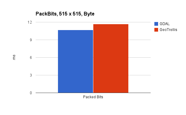
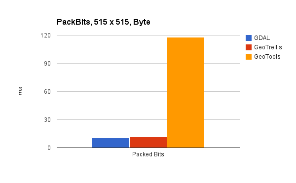
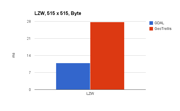
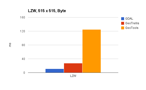
Compressions
- Huffman, CCITT3, CCITT4, Packbits
- LZW
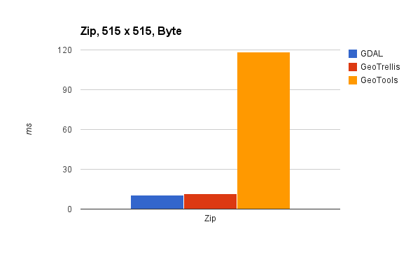
- Zip
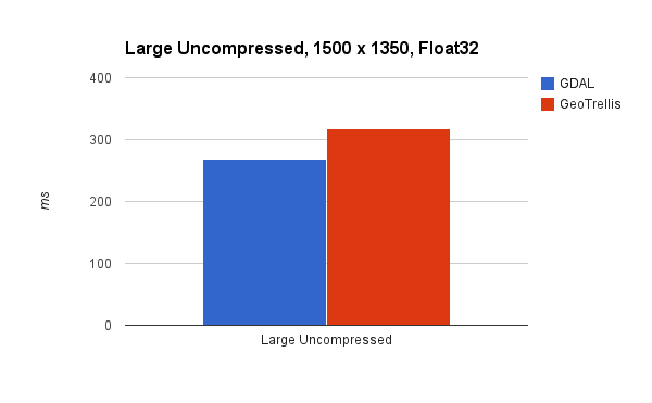
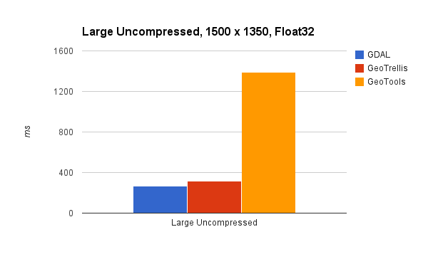
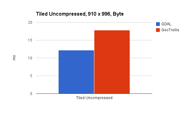
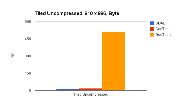
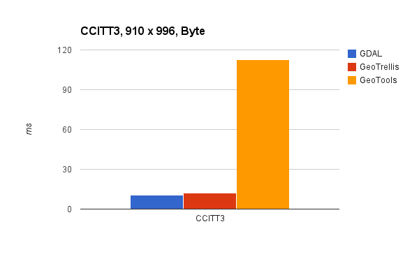
Benchmark Time!
Benchmark Disclaimer
- Ran on my development computer
- Conducted with Caliper
- Microbenchmarks, look at relative speed, not speed
- GDAL is read through the Java bindings, into GeoTrellis rasters
- GeoTools is also turned into GeoTrellis rasters
~same for CCITT3 and CCITT4
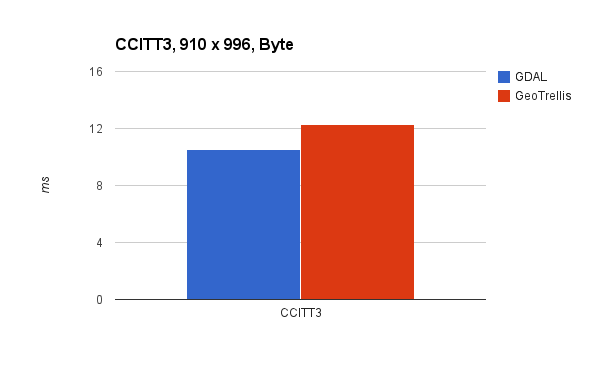
~same for CCITT3 and CCITT4

Sidenote about Speed
- Scala slow when using functional mappings
- Arrays, while loops and bit operations
- Skip Big-O time complexity analyzation (O(n) - duh), use microbenchmarks
Future?
- Tons of compressions, JPEG hard but needed
- Keep up to date with custom tags
- Add a shape file reader (GeoTools is fast!)
QUESTIONS?
Benchmarks found at https://github.com/geotrellis/benchmark